Livelink Explained: How Leica Cyclone FIELD 360 Delivers Your Data Before You Leave the Site
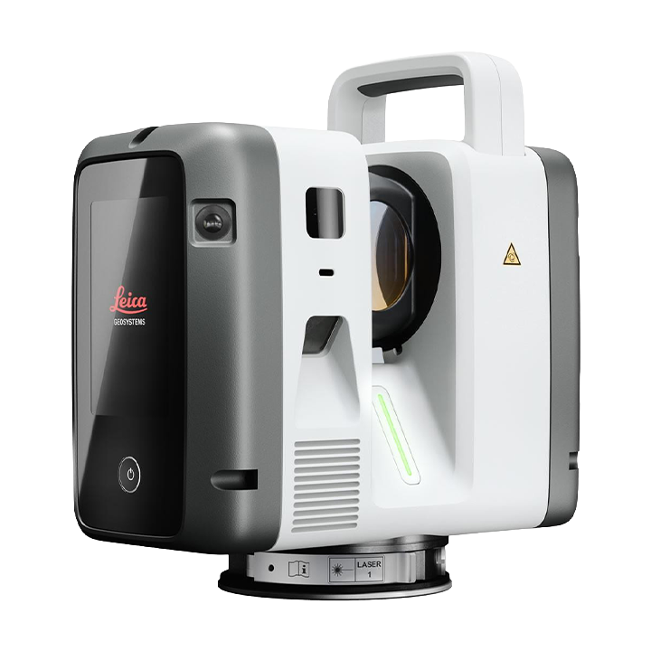
For as long as terrestrial laser scanning has existed, the workflow has been the same: scan on site, drive back to the office, import, register, share, and hope nothing was missed. If it was, that’s a return trip: travel time, remobilization, and a schedule hit that’s hard to explain to a client.
Livelink, a new capability in Leica Cyclone FIELD 360 and Hexagon GeoCloud, changes that sequence entirely, and it’s one of the least visible but most consequential parts of the new RTC Series launch.
It’s a workflow change rather than a hardware spec, which makes it easy to overlook on a comparison sheet but hard to overstate on an actual project. For construction teams, it’s also the most direct way to protect data integrity across a project: gaps get caught while the crew is still on site, not discovered weeks later as rework.
What Livelink Actually Does
Livelink streams scan data to Hexagon GeoCloud as its captured – not after the crew gets back to the office, but while the scan is still running. That means field and office teams are working on one live project, in real time, instead of the office waiting on a data dump at the end of the day.
No Missed Areas
The single most expensive failure mode in reality capture is discovering a coverage gap after the crew has already left the site. Livelink lets the field team verify scan completion on site, while they still have equipment set up and can fill the gap in minutes instead of scheduling a second mobilization weeks later.
Confidence Before You Leave
Because data streams live, a field lead can validate full coverage before wrapping up. Checking that every planned station registered cleanly, that there’s no unexplained gap in the point cloud, and that the data quality matches what the project actually needs. That confidence previously required a trip back to the office and a full import/register cycle before anyone could say for certain the scan was complete.
Remote Progress Monitoring
Office teams can watch scans being captured live and start registration sooner, rather than waiting for an end-of-day handoff. On multi-day or multi-crew projects, that means the office is never more than a few minutes behind. Field project managers can track progress against schedule in real time instead of end-of-week status calls.
Lower Project Risk, Standard Across the Series
The net effect across all of this is risk reduction: gaps get caught early, before they become rework or schedule overruns, and the office/field divide that used to introduce a full day of lag disappears. Livelink is included standard across the entire RTC Series. It isn’t a premium add-on reserved for the RTC700; every tier gets the same connected workflow.
On a project like this, the practical payoff of tighter baseline accuracy is fewer clash-detection false positives during MEP coordination, the model reflects the field, not the field plus a margin of scanner error the team has to mentally account for.
The Cost of the Old Workflow
It’s worth naming what the old workflow costs, because it rarely shows up as a single line item. A field team completes a multi-day scan, drives back, and only then discovers during import and registration that a stairwell or a mechanical room didn’t register cleanly. Now there’s a scheduling conversation: does the crew go back tomorrow, next week, or does the gap get flagged as a known limitation in the final deliverable? None of those options are good, and all of them were avoidable if the gap had been visible while the crew was still on site with equipment set up.
Multiply that scenario across a portfolio of projects in a year, and the return-trip cost. Travel, remobilization, schedule apologies to the client. All of that adds up to real money that never shows up as a “scanner cost” on any budget line.
Livelink in a Multi-Crew Environment
The benefit compounds on projects with more than one crew or more than one scanning day. Because Livelink streams to a shared GeoCloud project in real time, a second crew starting on day two can see exactly what the first crew already covered, instead of relying on a handoff conversation or a shared spreadsheet to avoid duplicate or missed coverage. Project managers overseeing multiple sites get the same visibility by being able to check progress against schedule from the office without waiting for an end-of-week status call.
Getting Started with Livelink
Livelink works through Leica Cyclone FIELD 360 on any RTC Series unit. There’s no separate hardware purchase or software license required to turn it on, since it’s included standard. The main set-up consideration is field connectivity: teams working in areas with limited cellular or Wi-Fi coverage should talk to ATG about connectivity requirements and offline capture options before relying on live streaming as the primary verification method on a given site.
Frequently Asked Questions
Does Livelink require a separate subscription?
Livelink is a capability within Leica Cyclone FIELD 360 and is included standard across the RTC Series, it’s part of the platform, not a paid add-on tier.
What happens to the data after it streams to Hexagon GeoCloud?
Field and office teams share one live project in GeoCloud, so registration can begin as soon as data arrives rather than waiting for the crew to return and manually import files.
Does this work without reliable site internet?
Livelink is built for field connectivity conditions common on construction and infrastructure sites; talk to ATG about connectivity requirements for your specific site conditions.
How ATG Helps You Implement Reality Capture
Adopting reality capture technology requires more than buying hardware. At ATG, we help organizations successfully implement advanced scanning solutions from start to finish:
- Customized Implementation & Protocols: We tailor workflows around your specific jobsite conditions, safety protocols, and operational goals.
- Software & Systems Integration: Raw point cloud data is only useful when actionable. ATG helps integrate scan data into your existing BIM, CAD, and asset management platforms to eliminate data silos.
- Hardware Ecosystem Strategy: We help you build the right toolset based on how you work, taking your project size, time on site, and other factors into consideration to recommend the right hardware for the job.
- Ongoing Training & Support: From initial evaluation and live demonstrations to team training, ATG provides continuous support to maximize your investment.
Connect field and office data seamlessly.
Whether you are upgrading from legacy hardware like the RTC360 or expanding your fleet for larger projects, the future of reality capture is connected, fast, and scalable.
Reach out to the ATG team today for a free consultation and demo – we take the time to understand your accuracy requirements and provide a recommendation based on your needs.