
Leica RTC Series Product Specifications
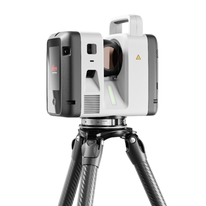
| Specification Category | RTC300 | RTC500 | RTC700 |
|---|---|---|---|
| GENERAL & SYSTEM | |||
| Type | High-speed 3D laser scanner with integrated High-Dynamic Range (HDR) spherical imaging system, cloud connectivity, highly accurate tilt compensation, and Visual Inertial System (VIS) for real-time registration. | ||
| Operation |
On scanner: 4.3" capacitive touchscreen, 480 x 800 colour display Mobile devices: Leica Cyclone FIELD 360 app (iOS/Android) for full remote scanner control, tagging, surveying workflows, and more. |
||
| Wireless & Data Storage |
Wireless: Integrated WLAN (802.11 a/b/g/n/ac/ax WLAN) 2.4 GHz and 5 GHz Band Storage: 512 GB internal solid-state drive (SSD) Transfer: USB-C (USB 3.2 Gen2) interface to external storage device |
||
| PERFORMANCE & SCANNING SPEED | |||
| Data Acquisition Speed | Up to 1,000,000 pts/sec | Up to 1,000,000 pts/sec | Up to 2,000,000 pts/sec |
| Scan & Image Speed | - | 2 min 30 sec (complete full dome scan & spherical HDR image at 5 mm @ 10 m) | 1 min 40 sec (complete full dome scan & spherical HDR image at 6 mm @ 10 m resolution); 30 s colour acquisition |
| Area Scan Capability | No | No | Yes (Up to 0.8 mm @ 10 m) |
| Surveying Workflows (via Cyclone FIELD 360) | Resection with targets | Resection with targets | Setup over known point, Known backsight, Resection, Traverse, Target measurements to 75 m, Targets from a full dome scan, Area scan from a full dome scan |
| Cloud Collaboration (Livelink) | Real-time field-to-office and crew-to-crew connectivity in Cyclone FIELD 360 and Hexagon GeoCloud. Enables remote project collaboration and multi-unit coordination. | ||
| Automatic Self-Calibration | Automatic self-calibration during normal operation—no user interaction or targets required. Status viewable in scanner GUI. | ||
| IMAGING SYSTEM | |||
| Camera System | 72 MP 6-camera system captures 432 MPx of raw HDR data for a calibrated 360° x 300° spherical image in 174 MPx resolution. | ||
| Image Performance | 30 s full spherical tone-mapped image in any lighting; 5-bracket tone-mapped HDR spherical imagery with auto exposure and auto white balance. | ||
| LiDAR & ACCURACY SPECIFICATIONS | |||
| Distance Measurement Technology | High-speed, high-dynamic time-of-flight enhanced by Waveform Digitising (WFD) technology | ||
| Laser Class / Wavelength | Laser Class 1 (IEC 60825-1:2014) / 1550 nm (invisible) | ||
| Beam Profile | Divergence: 0.5 mrad (1/e, full angle) | Diameter at front window: 6 mm (1/e³) | ||
| Field of View | 360° (Horizontal) / 300° (Vertical) | ||
| Range (Min / Max) | Min 0.5 m / Max 85 m (at 3.5% albedo) | Min 0.5 m / Max 130 m (at 8% albedo) | Min 0.5 m / Max 270 m (at 32% albedo) |
| Scan Resolutions (@ 10 m) | 3, 6, 12, 25 mm | 3, 6, 12, 25 mm | 1.6, 3, 6, 12, 25 mm (Area scan: 0.8 mm @ 10 m) |
| Angular Accuracy | - | - | 10" |
| Range Accuracy | - | - | 1.2 mm + 10 ppm |
| Range Noise | 0.2 mm @ 10 m | 0.4 mm @ 50 m | ||
| 3D Point Accuracy | 1.5 mm @ 10 m | 3.8 mm @ 50 m | ||
| INTEGRATED SENSORS | |||
| Visual Inertial System (VIS) | Video-enhanced inertial measuring system tracks scanner position and movements in real time. | ||
| Tilt Compensation |
IMU-based with automatic self-calibration Accuracy: 3" (upright/inverted, ±10° inclination) | 1' (any other inclination) |
||
| Additional Sensors | GNSS, Shock Sensor | ||
| DESIGN, ENVIRONMENTAL & POWER | |||
| Housing & Dimensions | Aluminium frame & side covers, ergonomic top handle | 121 mm x 240 mm x 254 mm (4.76" x 9.45" x 10.0") | ||
| Weight | 5.5 kg / 11.7 lbs (nominal, without batteries) | ||
| Mounting Mechanism | Quick mounting on 5/8" stub on lightweight Leica GST80 tripod; optional adapter for topographic tripod with 5/8" screw; optional survey tribrach adapter. | ||
| Operating / Storage Temp | -20°C to +50°C / -40°C to +70°C | ||
| Protection / Humidity | IP55 when upright/inverted (±15° inclination) | 95%, non-condensing | ||
| Power Supply |
Internal: 2 x Leica GEB461 rechargeable Li-Ion batteries (Up to 4 hours runtime, 340g each) External: Leica GEB282 AC power supply |
||
All specifications are subject to change without notice.
All accuracy specifications are on a level of confidence of 68% according to the Guide of the Expression of Uncertainty in Measurement (JCGM100:2008) unless otherwise noted.
* At 89% albedo.
** For single shot measurements.
*** For upright and upside-down setups with a ±15° inclination.
Scanner: Laser class 1 in accordance with IEC60825:2014.
iPhone and iPad are trademarks of Apple Inc.
Android is a trademark of Google.