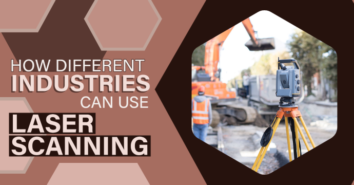
How Different Industries Can Use Laser Scanning
What is laser scanning?
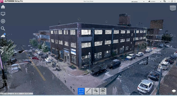
Simply put, laser scanning technology uses lasers to measure distances to objects or surfaces. The lasers capture measurements by calculating the speed at which the laser is reflected back to the scanner. These measurements are then spliced together to create a set of 3D coordinates, known as a point cloud. This data is then processed in software such as Autodesk ReCap Pro to create highly accurate 3D models of the environment.
Architecture & Construction
Did you know that up to 9% of a project’s total cost is wasted on rework (Ellis, 2023)? Not only does this drain resources, but it also takes a toll on team morale when they have to redo work they thought was approved. On top of that, around 28% of a project’s time is spent on rectifying rework and other issues (Procore, 2023). The key to preventing these annoying setbacks starts with taking action early, and reality capture tools can help set the foundation for a successful project.
By far the most common area reality capture tools are utilized, Architecture and Construction professionals can use this technology in a variety of ways. These innovative technologies provide accurate and detailed 3D models of structures, allowing professionals to use scans from the job site to assess spatial relationships, identify clashes, and plan renovations or expansions. This can be applied to a wide variety of structures as well, such as hospitals, residential buildings, offices, stadiums, and more. By incorporating reality capture throughout projects, professionals can improve quality and accuracy, reduce rework and costs, and eliminate the need for manual measurements.
Engineering & Surveying
The success and efficiency of any new civil engineering project relies heavily on conducting a comprehensive land survey. These projects often cover vast areas of land, with structures like roads and bridges that require thorough documentation. However, carrying out a meticulous land survey can be incredibly time-consuming and may result in potential project delays. Additionally, just like in Architecture and Construction, inaccurate measurements and inconsistencies from engineers can jeopardize the quality of the entire project.
Fortunately, advancements in technology have revolutionized the field of land surveying, offering engineers and surveyors incredible tools to streamline and expedite the process. With the aid of innovative solutions such as laser scanners, drones, and advanced mapping technology, professionals can now efficiently capture the land and generate highly detailed 3D models based on the collected data. This not only saves valuable time but also enhances accuracy and reduces the risk of errors or discrepancies.
By embracing these cutting-edge technologies, engineers and surveyors can greatly optimize their workflow, enabling them to complete land surveys with unparalleled efficiency and precision. This results in improved project management, faster turnaround times, and ultimately, a smoother and more successful project.
Mechanical, Electrical, and Plumbing (MEP)
Imagine a world where capturing existing conditions doesn’t require tedious measurements and manual notetaking. No more wasting weeks on this task that MEP professionals simply don’t have time for. Instead, picture yourself instantly accessing accurate and usable documentation for a site’s MEP systems. Thanks to reality capture technology, you can do just that – capture the intricate details of a building’s MEP systems with unparalleled precision.
MEP professionals can reap many benefits from utilizing reality capture technology. For example, capturing scans of a new building’s MEP systems can streamline future maintenance needs. With the ability to capture existing conditions in a fraction of the time, you’ll have more flexibility in your schedule to focus on what truly matters – delivering exceptional results to your clients.
Manufacturing
Manufacturing plants are full of complex industrial machinery and hard-to-reach places, making them nearly impossible to measure without putting workers at risk. Additionally, many plants run around the clock, so minimizing shutdown times to capture the site poses a significant challenge. However, manufacturers can also leverage the power of reality capture technology!
Reality capture in manufacturing offers a multitude of applications and a wide range of benefits. Factories can deploy laser scanning for various purposes, such as modernizing, remodeling, relocating, and even investigating plants for potentially hazardous practices. Gathering this vast amount of 3D data can also help with planning and improving operational costs. The user-friendly nature of laser scanning technology not only reduces shutdown times but also fosters a safe environment by capturing those out-of-reach areas without getting in the way of production.
In addition to capturing the area of the plant, laser scanning technology can be deployed by manufacturers for prototyping and product engineering. This innovative approach not only reduces production times but also accelerates product testing and eliminates the requirement for manual measurements during the design process.
Forensics & Crime Investigation
Accurately capturing all the necessary evidence within a limited time frame is a daunting task when relying on traditional forensics tools like cameras and tape measures. The unpredictable nature of crime, occurring anywhere and anytime with varying types of evidence, adds to the complexity. Additionally, crime scenes are bustling with police officers, EMTs, firefighters, and detectives, making is even more challenging to navigate through the site.
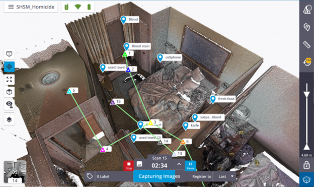
With the use of laser scanning technology, detectives can quickly capture precise and detailed 3D data of crime scenes and physical evidence. These tools also enable photo tagging within the scan, connecting evidence shown in the point cloud to actual photos from the crime scene. Another benefit is that the scanner does not rely on light to scan the scene, making the process of gathering evidence even more accessible. Once all the pieces are put together, investigators are left with a walkable representation of the scene that they can revisit at any time for a thorough review.
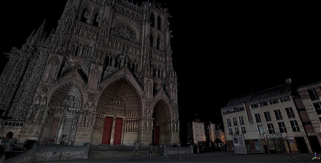
Historical Preservation
Documenting, preserving, and restoring historical structures comes with many challenges. Unlike modern construction, historical structures boast unique elements that are rarely seen today. Intricate details such as statues, masonry, and wood carvings are hard to capture accurately, especially when done by hand. Additionally, the condition of these monuments is not always optimal, making them potentially hazardous to explore due to deterioration over time. On top of that, these structures can be incredibly delicate, putting them at risk of further damage when workers are present.
By utilizing laser scanning technology, historical preservation becomes a hands-off process. This means that instead of physically interacting with the site, you can simply place the scanner and capture the surroundings. These scanners can go beyond surface level to catch what’s not visible to the naked eye, revealing hidden imperfections such as foundation shifts, asymmetry, and other flaws. This wealth of information provides a precise representation to those restoring the site, enabling them to easily identify and rectify any issues to ensure preservation of the site.
Aerospace
The consequences of an aircraft engine or critical part failure can be catastrophic. That’s why inspections and testing play a vital role in the construction and maintenance of aircraft. When it comes to these inspections, non-destructive testing (NDT) is the preferred method over destructive testing because it allows for the identification of safety issues without causing damage to aerospace materials. Destructive testing, on the other hand, involves cutting, grinding, or drilling materials to identify issues, rendering them useless after inspection. Furthermore, traditional NDT methods may not be suitable for inspecting certain aerospace materials or hard-to-reach areas, as they can be intrusive and potentially cause damage.
With the use of laser scanning, aerospace professionals can easily and quickly capture detailed 3D data of aircraft components without any direct interaction. This innovative technology enables truly non-destructive testing methods, eliminating the risk of damage while providing access to confined and hard-to-reach areas.
Forestry
Every year, deforestation claims over 15 billion trees (8billiontrees.com), prompting companies to seek sustainable solutions that minimize human impact. In the forestry industry, data plays a crucial role in assessing the damage caused by logging and wildfires, tracking tree height and structure, and facilitating forest planning and management. While satellites offer a means of capturing forest data, their limitations prevent them from providing the precise details necessary for a comprehensive overview of large areas.
Laser scanning technology in forestry offers a wide range of applications, including capturing valuable data for forest mapping, monitoring pollution levels, and estimating carbon absorption. This information can be effortlessly recorded using fixed-position scanners, drones, and handheld scanners, enabling efficient data collection across vast areas in a short period of time. As a result, gathering comprehensive data from the area becomes easier and more streamlined.
Conclusion
This is not an exhaustive list of all industries that can utilize laser scanning. If you require precise measurements in any aspect of your work, you may be able to utilize laser scanning to improve and streamline your workflow. While reality capture tools alone can’t solve all the challenges these industries face, using them alongside other software, hardware, and resources is a crucial step to overcome them.
If you’re eager to experience the wonders of reality capture technology yourself, consider outsourcing your laser scanning needs for a seamless solution. At ATG we boast a team of seasoned reality capture experts who can effortlessly scan your site, register your point cloud, and even create a model from the data, all without the hassle of purchasing your own scanner or additional training. This efficient and cost-effective approach ensures you have the support of a knowledgeable team every step of the way.

2 Responses