What’s new in Civil 3D 2025?

As civil engineers and designers, we know that efficiency and precision are key to successful project execution. With the release of Civil 3D 2025, Autodesk has taken significant strides to enhance our workflow, making complex designs more manageable than ever. Here’s a look at the standout features that are set to transform the way we work.
Streamlined Interface for Enhanced Selection
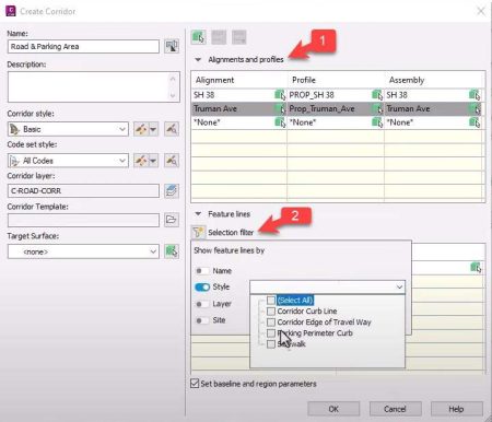
[1] One of the most exciting updates in Civil 3D 2025 is the revamped interface that allows users to select multiple alignments and feature lines simultaneously from the design file. This means that when users select an alignment, users will be prompted to choose the associated design profile and assembly in one smooth workflow.
[2] The introduction of a selection filter adds another layer of efficiency. Users can easily sort feature lines by name, style, or layer, and using the Shift key, users can select multiple feature lines at once. This flexibility not only saves time but also ensures that users can focus on the elements that matter most.

Efficient Multi-Baseline Corridor Creation
With the new selection tool, the creation of complex, multi-baseline corridors has never been easier. Users can apply names to any unnamed feature lines or choose to exclude them from usersr selection. Once users hit “OK,” the selected alignments, feature lines, and assemblies appear in the corridor parameters dialog box, allowing for a seamless setup process.
This functionality enhances the user’s ability to design intricate corridors quickly and efficiently, providing a significant boost to usersr productivity.

Accurate Control with Vertical Datums
Accurate design elevations are crucial for any civil project. Civil 3D 2025 allows users to assign vertical datums easily, thanks to the new ENABLEVCSSUPPORT feature. This enhancement helps control design elevations with greater accuracy. When adding DEM files, the user can assign coordinates.
Enhanced Mapping Features
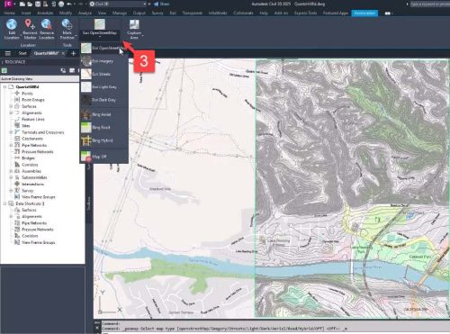
Another noteworthy addition is the integration of Esri mapping features in the geolocation tab. Users can now access high-resolution aerial views and various street maps, which provide extensive and accurate details for users projects. This enhancement ensures that users have the best possible context for users designs, leading to better-informed decisions.

Improved Performance Across the Board
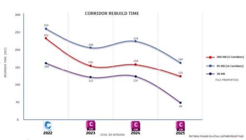
Civil 3D 2025 is not just about new features; it also boasts significant performance improvements. Tasks such as opening files, saving, regenerating details, and rebuilding corridor models are now faster than ever. The improved response times are particularly beneficial when working with large design files that involve multiple corridors, extensive pipe networks, and expansive surfaces.
Additionally, MMS files will only update when changes are made to the surface, helping to streamline processing time and improve overall efficiency.

Conclusion
The advancements in Civil 3D 2025 are poised to make a substantial impact on how civil engineers approach their projects. With an intuitive interface, enhanced mapping capabilities, and improved performance, Autodesk is making it easier than ever to create accurate and complex designs. Whether users managing large projects or fine-tuning details, Civil 3D 2025 is here to elevate user workflow. Embrace these new features and watch user efficiency soar!


